31 m away
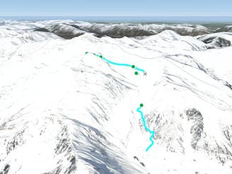
Hike and Ride Grübelspitze to Juns

Hike and Ride Route in the area of Eggalm. Bus ride back required
Difficult Freeride Skiing
- Distance
- 4 km
- Ascent
- 204 m
- Descent
- 992 m
Beautiful route on the Beilspitz NW face
Freeride Skiing Difficult

From the top of the Beilspitz Lift, the only T-Bar in this area, go straight over the ridge in a NW direction. You have a breathtaking view down the hill now, which is shady until late afternoon. When you drop into the wide slope you will notice a road crossing in about 200 m and some trees in 350 m, which you should pass on the right side. From there the hill steepens slightly, but you have enough space for some long joyful turns. You can go straight down into the valley with a descent of 500m here. If you want to do a tree run, maybe when the vis isn't that good, than you can stay further right for better orientation. At the bottom of the valley you will notice a road leading into the woods, follow it until you reach a crossing and take the next road on the left until you reach the red slope number 77 to the Eggalm Nord chairlift. This route is most best in January or February, when you have a fresh powder in the valley. If you love big turns this is your hill in Mayrhofen!
Difficult
Serious gradient of 30-38 degrees where a real risk of slipping exists.

As well as the slope itself, there are some obstacles (such as rock outcrops) which could aggravate injury.

Little chance of being seen or helped in case of an accident.
31 m away
Hike and Ride Route in the area of Eggalm. Bus ride back required
Difficult Freeride Skiing
5.8 km away
Long and delightful route down the Horberg Valley
Difficult Freeride Skiing
6 km away

A spectacular run on the E face of Wanglspitz
Severe Freeride Skiing
6 km away

Steep challenging couloirs for experts only.
Extreme Freeride Skiing
6 km away

Delightful ride from Wanglspitz onto its' North face into the Hoarbergkar
Difficult Freeride Skiing
6 km away

Short powder run, easy on sunny days and usually safe on foggy ones.
Moderate Freeride Skiing
7.5 km away

Freeride route with 300m of easily accessible powder,
Difficult Freeride Skiing
8.3 km away

This route is a classic line here in Hintertux. Easy accessible, there is only a short hike needed.
Difficult Freeride Skiing
8.3 km away

A short hike for long and joyful descent
Difficult Freeride Skiing
8.8 km away

An easy route with a short hike which is nice on busy days
Difficult Freeride Skiing

7 routes · Freeride Skiing
6 routes · Freeride Skiing
7 routes · Freeride Skiing

10 routes · Freeride Skiing

10 routes · Freeride Skiing