4 m away
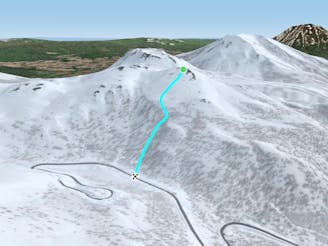
Nito Ascent SW

The most direct of the three options to ascend Nito.
Difficult Freeride Skiing
- Distance
- 1 km
- Ascent
- 236 m
- Descent
- 1 m
The most difficult but possibly most rewarding of the three options to ascend Nito.
Freeride Skiing Moderate

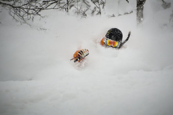
Though the most difficult of the three options for ascending Nito, this route can be very rewarding, particularly on storm days, as the terrain accessed is delightful. That said, ascending this route takes more snow than all the other routes, and involves some potentially tricky navigation. It is also rarely set for you, meaning you have to do all your own work.
From the trailhead, follow the road as it follows a gentle bend to the walker's left, W, but leave this just after crossing the large creek. Follow the creek on the left hand side until you can enter the creek bed. If there is too much open water in the creek bed this route is not possible and one will have to ascend a different route. If this is the case, it is not recommended to attempt to ski out this way as it is rather difficult and requires a narrow, exposed traverse.
If able to enter the creek bed, do so, and follow it to the waterfall, before regaining the steep river back to the climbers left. There is another creek that joins the river just before the waterfall, that is sometimes an easy spot to get up onto this patch of land. Walk up through the widely spaced trees while trending to the right. After about 50 metres of ascent, there will be a rib running to the SW. Use this as a right handrail and continue up the open, S/SE facing slope until on the bench where the trees tend to thin out. From here, if it is a storm day, the skiing can be quite good. See Nito SE and Nito S Nose.
If weather permits continue upward, trending to the right, though remaining to the left of the large hump that is a false summit. Your right foot will be your high foot for most of this climb. It is about 150 metres until the proper summit, and the false summit is an annoyingly long process to gain. If frustrated or tired, one can drop in to the right anywhere along this mellow ridge.
Once on the summit, you will have successfully walked up most of the terrain and snow you will be skiing on. Be wary as the bowl immediately below to the east is a large start zone that is frequently loaded by dominant winds. That said, it is excellent skiing if it is assessed to be safe. There are several options down from the top including Nito SE, Nito S nose, Nito SW, Nito SW Nose, Nito NW, and Nito W.
Moderate
Slopes become slightly steeper at around 25-30 degrees.

As well as the slope itself, there are some obstacles (such as rock outcrops) which could aggravate injury.

In the high mountains or remote conditions, all individuals must be completely autonomous in every situation.
4 m away
The most direct of the three options to ascend Nito.
Difficult Freeride Skiing
5 m away

The easiest of the three options to ascend Nito.
Moderate Freeride Skiing
587 m away

An exciting storm day run with relative easy access and an easy return.
Difficult Freeride Skiing
959 m away

An exciting storm day run and great way to return to the trailhead after touring other sections of Nito.
Difficult Freeride Skiing
972 m away

A great storm day touring zone with pleasantly spaced trees and sheltered spots for transitions.
Moderate Freeride Skiing
1.2 km away

A great run on a clear day that takes you from the top of Nito all the way down the S/SE face.
Difficult Freeride Skiing
1.2 km away
A classic run from the summit of Nito that keeps riders high and close enough to the summit for more laps.
Moderate Freeride Skiing
1.2 km away

The classic route up Chisenupuri. It is not recommended to go higher than the top of the old lift system on storm days.
Difficult Freeride Skiing
1.2 km away

A great storm day touring zone with lots of sheltered spots and features that fills in later in the winter.
Difficult Freeride Skiing
1.2 km away

A classic run from the summit of Nito that keeps riders high and close to the summit for more laps.
Difficult Freeride Skiing
12 routes · Freeride Skiing