24 m away
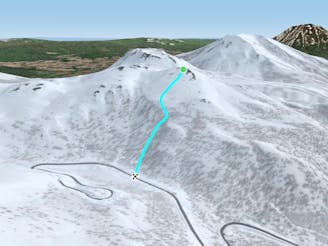
Nito SW Nose

An exciting storm day run and great way to return to the trailhead after touring other sections of Nito.
Difficult Freeride Skiing
- Distance
- 625 m
- Ascent
- 0 m
- Descent
- 225 m
A great storm day touring zone with pleasantly spaced trees and sheltered spots for transitions.
Freeride Skiing Moderate

This is a fun and classic W facing run on storm days. It brings you from about 100 metres below the summit of Nito back down to Route 66 close to your skin track, so taking multiple laps is very feasible.
To get to this run, it is recommended to follow the Nito Ascent W route. Follow this to the bench where the trees begin to thin. If weather allows it is possible to ski this run from the top of Nito. Remember to check the local Nadare Forecast (linked below) before heading into the backcountry.
From the bench, access is very simple: drop in to the tree filled bowl you skinned back up. The run is about 150 metres, and ends gradually at the road. One can explore to the riders left by skiing along the bench before dropping in. There are several small terrain features that make up several different bowls in this zone, all are west/south-west facing.
Be wary there is one significant creek that follows the road. You will have walked by this creek when bypassing the switchback in the road before the bridge, so it will not be an unfamiliar obstacle. In December, this creek is still exposed but by January it is usually filled in and is simply a deep concavity.
A nice linkup involves skiing this zone and taking the Nito SW, Nose run as a return to the trailhead.
Moderate
Slopes become slightly steeper at around 25-30 degrees.

As well as the slope itself, there are some obstacles (such as rock outcrops) which could aggravate injury.

In the high mountains or remote conditions, all individuals must be completely autonomous in every situation.
24 m away
An exciting storm day run and great way to return to the trailhead after touring other sections of Nito.
Difficult Freeride Skiing
440 m away

An exciting storm day run with relative easy access and an easy return.
Difficult Freeride Skiing
481 m away
A classic run from the summit of Nito that keeps riders high and close enough to the summit for more laps.
Moderate Freeride Skiing
494 m away

A great run on a clear day that takes you from the top of Nito all the way down the S/SE face.
Difficult Freeride Skiing
504 m away

A classic run from the summit of Nito that keeps riders high and close to the summit for more laps.
Difficult Freeride Skiing
515 m away

A great storm day touring zone with lots of sheltered spots and features that fills in later in the winter.
Difficult Freeride Skiing
967 m away

The easiest of the three options to ascend Nito.
Moderate Freeride Skiing
968 m away

The most direct of the three options to ascend Nito.
Difficult Freeride Skiing
972 m away

The most difficult but possibly most rewarding of the three options to ascend Nito.
Moderate Freeride Skiing
1.4 km away

A steep and playful east facing run that infrequently gets skied and can hold snow days after a storm.
Moderate Freeride Skiing
12 routes · Freeride Skiing