1 m away
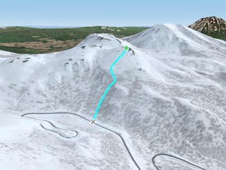
Nito Ascent SW

The most direct of the three options to ascend Nito.
Difficult Freeride Skiing
- Distance
- 1 km
- Ascent
- 236 m
- Descent
- 1 m
The easiest of the three options to ascend Nito.
Freeride Skiing Moderate

This line - the physically easiest route up Nito - follows a route with the fewest switchbacks and portions of tight trees. It is also the most popular, so if you are less inclined to set your own skin track, it will be most likely someone has done the work for you up this side of Nito.
From the trailhead, follow the road as it follows a gentle bend to the walker's left. W. You will pass by a blue road sign that, depending on snow coverage, will be well above head height, or nearly buried. Keep in mind this is a sign over the road, as it is a good indicator of how much snow is covering hazards such as creeks and holes.
Continue to follow the road for another 100 metres, until shortly before the bridge. At this point, branch to the right and continue gently uphill through the trees. You will cross a creek, and about 100 metres after leaving the road, will see it again on your left, trending N. Regain the road and walk along it until the road bends back to the W.
If snow coverage is low, use the road to cross the creek at the bend, before ascending the W face of Nito. There is a small concavity that runs to the climbers left of the open stand of trees you will be walking under. Use this as a handrail, bouncing your switchbacks off of it until you reach a bench where the trees begin to thin out. At this point you will still be low and in the trees enough to make a relatively sheltered transition and take laps off the W facing terrain- a 150 metre run that is quite fun.
If weather allows, continue skinning up, trending along and above the bench to the N/NE for another 150 metres. One can wrap around the N side of the peak for some tremendous views of the ocean as the route indicates on the map, or switchback up the S face to stay in the sun, and wait until the top for the view.
If intending to ski the W face of Nito, you will have successfully walked up most of the terrain and snow you will be skiing on. A straightforward assessment of things will be feasible. There are several options down from the top including Nito W, Nito NW, Nito SW Nose, Nito SW, Nito S nose and Nito SE.
Moderate
Slopes become slightly steeper at around 25-30 degrees.

Exposure is limited to that of the slope itself. Getting hurt is still likely if the slope is steep and/or the snow is hard.

In the high mountains or remote conditions, all individuals must be completely autonomous in every situation.
1 m away
The most direct of the three options to ascend Nito.
Difficult Freeride Skiing
5 m away

The most difficult but possibly most rewarding of the three options to ascend Nito.
Moderate Freeride Skiing
583 m away

An exciting storm day run with relative easy access and an easy return.
Difficult Freeride Skiing
954 m away

An exciting storm day run and great way to return to the trailhead after touring other sections of Nito.
Difficult Freeride Skiing
967 m away

A great storm day touring zone with pleasantly spaced trees and sheltered spots for transitions.
Moderate Freeride Skiing
1.2 km away

A great run on a clear day that takes you from the top of Nito all the way down the S/SE face.
Difficult Freeride Skiing
1.2 km away
A classic run from the summit of Nito that keeps riders high and close enough to the summit for more laps.
Moderate Freeride Skiing
1.2 km away

A great storm day touring zone with lots of sheltered spots and features that fills in later in the winter.
Difficult Freeride Skiing
1.2 km away

The classic route up Chisenupuri. It is not recommended to go higher than the top of the old lift system on storm days.
Difficult Freeride Skiing
1.2 km away

A classic run from the summit of Nito that keeps riders high and close to the summit for more laps.
Difficult Freeride Skiing
12 routes · Freeride Skiing