23 m away
Nito NW
A classic run from the summit of Nito that keeps riders high and close enough to the summit for more laps.
Moderate Freeride Skiing
- Distance
- 737 m
- Ascent
- 0 m
- Descent
- 287 m
A classic run from the summit of Nito that keeps riders high and close to the summit for more laps.
Freeride Skiing Difficult

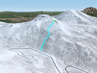
This is a fantastic W facing run that brings you from the summit of Nito back to the the upper section of Route 66 that is closed in the winter. It is perfect for taking multiple laps off the summit of Nito on longer days when snow is staying good to the W. It has a steep and exciting entrance with several cliffs at the top of the run, and small stumps and features to jump off down low as the run levels off.
To get to this run, it is recommended to follow the Nito Ascent W route, as this will put you on the same aspect you will be skiing, for a better assessment of the snow. Remember to check the local Nadare Forecast (linked below) before heading into the backcountry.
From the summit of Nito, follow the ridge towards the lower summit to the N, about 100 metres away. Depending on snow conditions, it may be easier to traverse on skins over to this second summit rather than start from the summit of Nito. There is a summer hiking trail from this north summit, sometimes visibly marked by wooden signs early in the season before they become buried. From this point, the descent will be clear, to the W or SW depending on where looks more desirable.
The top section has three main shots, all denoted by rocky outcrops near the top. If snow is good, these rocks are possible to jump off regardless of snow conditions, but they can be quite exhilarating to ski around and through. The run remains clean below the main rock formations, and opens up later in the season as things fill in. Generally speaking, the riders left hand of the three shots is the most open. As the run begins to level off, more trees and bushes become buried and form hits and features to jump off. Keep your speed up near the bottom to make it back to the road.
Once on the road, descent to the riders left, back towards the car, and put skins back on when you reach your skin track from the way up to go get more!
Difficult
Serious gradient of 30-38 degrees where a real risk of slipping exists.

As well as the slope itself, there are some obstacles (such as rock outcrops) which could aggravate injury.

In the high mountains or remote conditions, all individuals must be completely autonomous in every situation.
23 m away
A classic run from the summit of Nito that keeps riders high and close enough to the summit for more laps.
Moderate Freeride Skiing
23 m away

A great storm day touring zone with lots of sheltered spots and features that fills in later in the winter.
Difficult Freeride Skiing
40 m away

A great run on a clear day that takes you from the top of Nito all the way down the S/SE face.
Difficult Freeride Skiing
490 m away

An exciting storm day run and great way to return to the trailhead after touring other sections of Nito.
Difficult Freeride Skiing
504 m away

A great storm day touring zone with pleasantly spaced trees and sheltered spots for transitions.
Moderate Freeride Skiing
667 m away

An exciting storm day run with relative easy access and an easy return.
Difficult Freeride Skiing
1.2 km away

The easiest of the three options to ascend Nito.
Moderate Freeride Skiing
1.2 km away

The most direct of the three options to ascend Nito.
Difficult Freeride Skiing
1.2 km away

The most difficult but possibly most rewarding of the three options to ascend Nito.
Moderate Freeride Skiing
1.8 km away

A steep and playful east facing run that infrequently gets skied and can hold snow days after a storm.
Moderate Freeride Skiing
12 routes · Freeride Skiing