23 m away
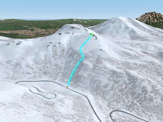
Nito W

A classic run from the summit of Nito that keeps riders high and close to the summit for more laps.
Difficult Freeride Skiing
- Distance
- 1.2 km
- Ascent
- 4 m
- Descent
- 296 m
A great storm day touring zone with lots of sheltered spots and features that fills in later in the winter.
Freeride Skiing Difficult

This is a fun variation on the classic W facing runs off of Nito. It gets a lot of sun due to its SE facing nature, and is a bit more difficult to access than the other runs. Though it is usually worth the effort, as this run has far more features than the other zones. It is a less straightforward hike as well as return but if you're familiar with the terrain, one can ski all the way back to the trailhead from this zone.
To get to this run, it is recommended to follow the Nito Ascent S route. Though this may not be the easiest way up the terrain, it is by far the most straightforward, and requires the least amount of walking. From the bench where the trees begin to thin, one can continue to the N up the ridge until the terrain looks inviting. You know you are looking at the right E facing bowl because there is a large tower denoting the south end of the bowl.
From there, the bowl runs N and one can drop in wherever they see fit. The tight trees at the top open up after the first several turns, to a wide open playground of widely spaced trees, humps and stumps to launch off of. The terrain benches after roughly 150 metres, depending on how high up the ridge you ascended. Particularly if skiing this zone before February, stop immediately as the terrain levels off for two reasons. First, there is a large creek that rarely fills in completely, and frequently has snowdrifts that overhang the creek banks. Second, it makes the return much easier.
To return, either for another lap, or to get back to the trailhead, traverse and follow the creek bed S. You will round a corner that may require a short sidestep to get around before being able to head uphill again, or down and out. This route can be tedious for snowboarders in deep snow. Because this zone is a bit more difficult to access, it is a good idea to take multiple laps through here, so bring lots of snacks and water for a longer day.
When heading out, be wary of the creek if you accessed this zone in early season. It is recommended to either walk up the creek bed from the road so you know which obstacles you will encounter, or hike back to the bench, and ski to the Nito SW descent to return to Route 66. If doing this, remember to be careful of the water bar before the road. Once on the road, follow it to the left past the big blue road sign and back to the trailhead.
Difficult
Serious gradient of 30-38 degrees where a real risk of slipping exists.

As well as the slope itself, there are some obstacles (such as rock outcrops) which could aggravate injury.

In the high mountains or remote conditions, all individuals must be completely autonomous in every situation.
23 m away
A classic run from the summit of Nito that keeps riders high and close to the summit for more laps.
Difficult Freeride Skiing
29 m away

A great run on a clear day that takes you from the top of Nito all the way down the S/SE face.
Difficult Freeride Skiing
38 m away
A classic run from the summit of Nito that keeps riders high and close enough to the summit for more laps.
Moderate Freeride Skiing
501 m away

An exciting storm day run and great way to return to the trailhead after touring other sections of Nito.
Difficult Freeride Skiing
515 m away

A great storm day touring zone with pleasantly spaced trees and sheltered spots for transitions.
Moderate Freeride Skiing
662 m away

An exciting storm day run with relative easy access and an easy return.
Difficult Freeride Skiing
1.2 km away

The easiest of the three options to ascend Nito.
Moderate Freeride Skiing
1.2 km away

The most direct of the three options to ascend Nito.
Difficult Freeride Skiing
1.2 km away

The most difficult but possibly most rewarding of the three options to ascend Nito.
Moderate Freeride Skiing
1.8 km away

A steep and playful east facing run that infrequently gets skied and can hold snow days after a storm.
Moderate Freeride Skiing
12 routes · Freeride Skiing